
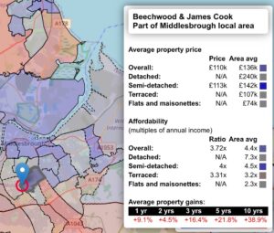
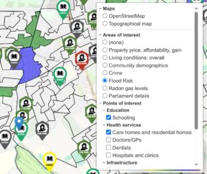
House prices, affordability, price rises
We hold detailed property data for over 5,000 areas in England. We also compare these against the average for the local area district. See not only the property costs, but also their value against the surrounding areas.
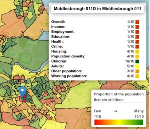
Living conditions in your chosen area
We have detailed statistics for over 30,000 areas in England. These cover health, education, employment, housing quality, and many others.
We also hold age demographics and population density data, allowing you to find areas for your preferred age bracket and family values.
We also hold age demographics and population density data, allowing you to find areas for your preferred age bracket and family values.
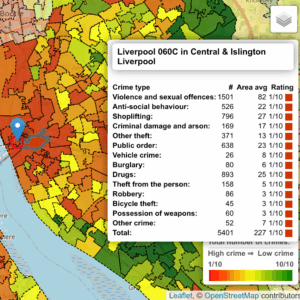
Crime
We hold details on over 5,000,000 crimes for the last year, across all types of criminal activities, covering over 30,000 individual areas. As well as the location of all prisons.
Find safe areas for your family. Avoid crime hotspots. Breathe easy.
Find safe areas for your family. Avoid crime hotspots. Breathe easy.
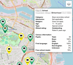
Schooling
We have details on over 28,000 schools across all ages, holding not only Ofsted ratings, but also detailed breakdown on school size, age groups, gender mix, spoken languages, and free school meals eligibility.

Health institutions
We have details on over 19,000 doctors' surgeries, 25,000 dentists, 2,000 hospitals, 9,000 nursing homes, 25,000 residential homes, and many others. These include their CQC ratings across all areas of care.
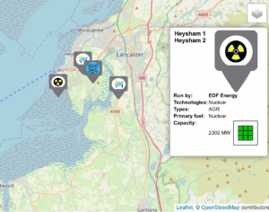
Unwanted infrastructure
We hold information about all sorts of unwanted infrastructure around you: Windmills, solar farms, gas burners, nuclear power plants, prisons, landfills, and waste dumps, whether these are still operating, or historic sites that can still pose a health risk.
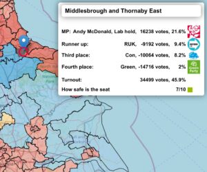
Want to learn more about our parliament in your chosen area?
We have the latest parliament breakdown, allowing you not only to find your local MP, but also see the latest election results: Winners, runner ups, third and fourth place, margins, turnout, and how safe the seat is.
We are giving away Cornwall!
Don't take our word for it. We are giving away all of Cornwall in a free map. Try all the overlays. Sample the data that we hold.
See how this will revolutionise your way of researching your new home. Know Your Area.
See how this will revolutionise your way of researching your new home. Know Your Area.
I almost put an offer in on a house that looked perfect, until I checked Know Your Area and saw the flood risk data. We found a safer home two streets away. This tool is a lifesaver.

Sarah J., Mum of two